What is a cross-country flight?

The FAA defines a cross-country flight in two ways depending on the context. For logging purposes, a cross-country is any flight with a landing at a point other than the departure airport that involves use of dead reckoning, pilotage, electronic navigation, or radio aids — and is more than 50 nautical miles straight-line from the departure airport. For the PPL solo cross-country requirement, at least one leg must be 50+ nm from the departure point.
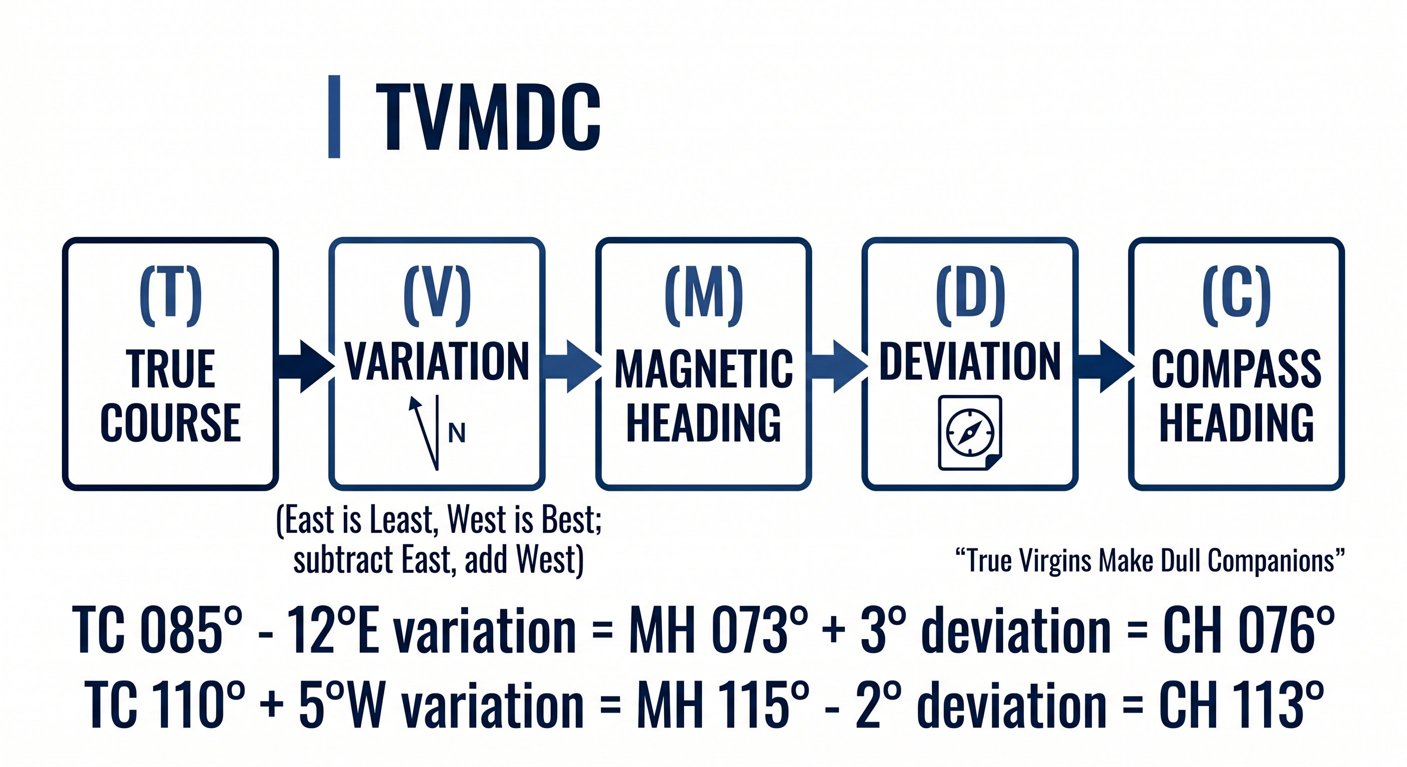
True to compass — TVMDC conversion for XC navigation
The solo cross-country requirements for a Private Pilot License are:
64 free PPL ground school videos on YouTube. Also offers a premium interactive course at freepilottraining.net with 700+ practice questions and a written exam endorsement.
- 5 hours of solo cross-country time
- One cross-country of at least 150 nm total with full-stop landings at a minimum of 3 points, one leg at least 50 nm straight-line from departure
Cross-country planning is a critical checkride topic. Your DPE will almost always work through a cross-country plan with you during the oral exam and assign a new destination during the flight test. Master this process completely.
Step 1 — Route selection
Start by picking your destination and drawing the most direct route on a sectional chart. Then evaluate that route for the following before committing:
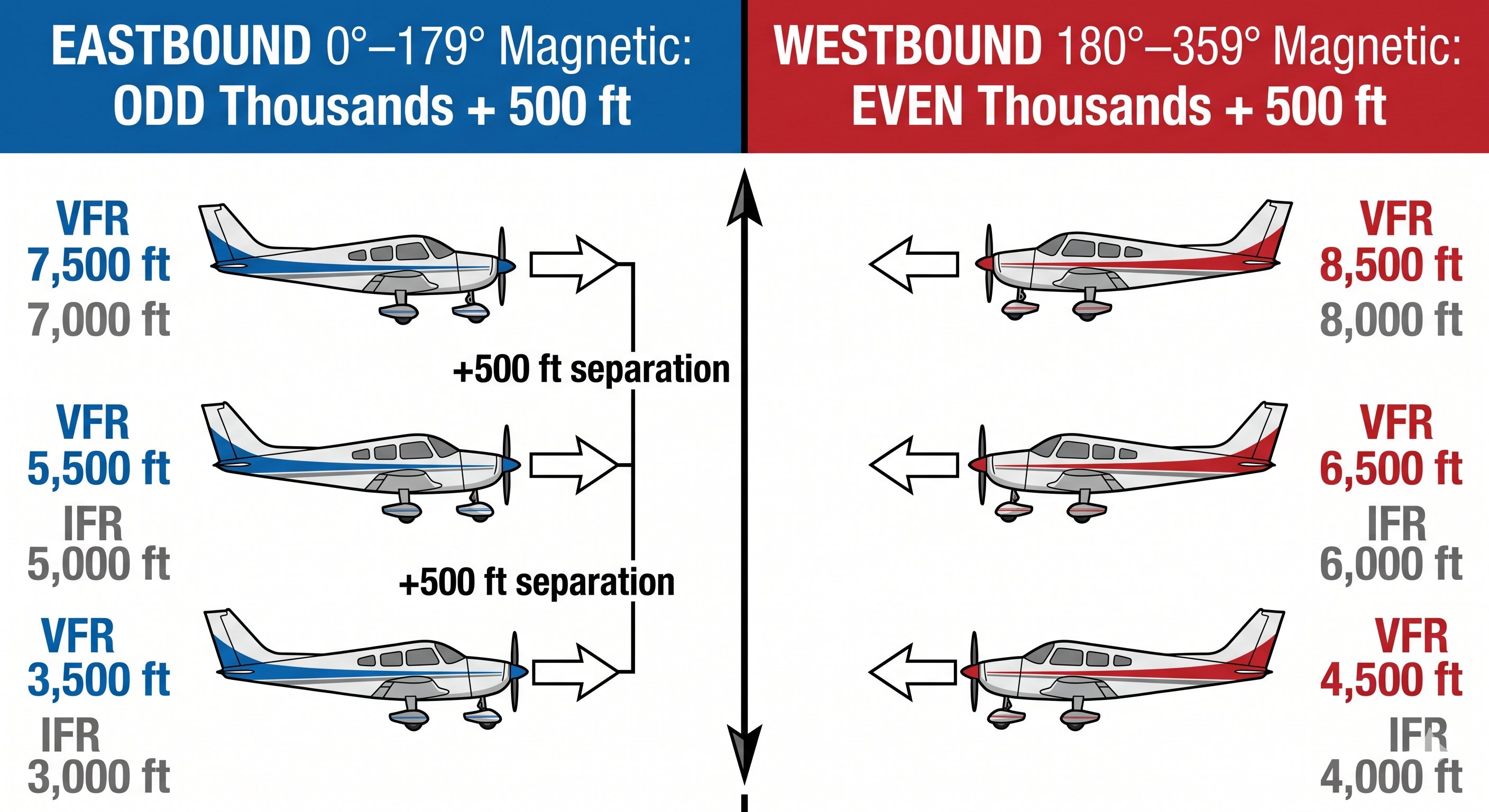
VFR cruising altitudes — odd eastbound, even westbound, plus 500
- Terrain — are there mountains, ridges, or terrain that require minimum crossing altitudes? VFR pilots must maintain 500 ft above the highest obstacle within 4 nm of the route in non-mountainous areas, and 2,000 ft above the highest obstacle within 4 nm in mountainous areas.
- Airspace — does the route pass through or under any Class B, C, or D airspace? Military operating areas? Restricted or prohibited areas? Mark them on your sectional.
- Landmarks — identify prominent visual checkpoints every 10–15 nm: towns, rivers, lakes, highways, airports. These are your dead reckoning confirmation points.
- Fuel stops — can you complete the route with required reserves, or do you need to stop? Never depart without completing the fuel calculation.
- Alternate airports — identify airports along the route where you could divert if weather deteriorates or you have an emergency.
Choosing cruise altitude
VFR altitude rules (FAR 91.159) require: when flying on a magnetic course of 0°–179°, fly at odd thousands + 500 ft (3,500, 5,500, 7,500). When flying on a magnetic course of 180°–359°, fly at even thousands + 500 ft (4,500, 6,500, 8,500). Below 3,000 ft AGL, the hemispheric rule doesn't apply.
Choose altitude based on terrain clearance, wind (winds aloft forecast), airspace, and aircraft performance. Higher altitudes typically provide better glide distance in an emergency and more favorable winds for long flights.